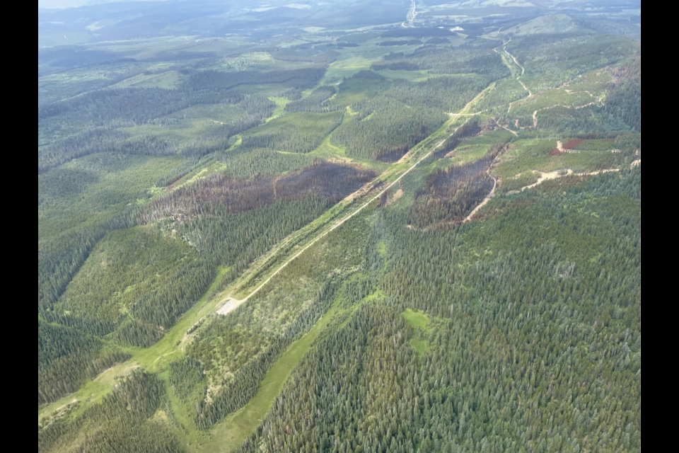
MD OF BIGHORN – A wildfire in the northeastern reaches of the MD of Bighorn is now classified as being held.
After a week of battling the blaze 25 kilometres west of Water Valley with the help of firefighters, engines, helicopters, air tankers and heavy equipment to establish a fire guard, wildfire officials now expect the fire to stay contained at 65.4 hectares.
“This means that given the current resources and anticipated weather, the wildfire is not expected to grow beyond pre-determined boundaries,” states the latest update from Alberta Wildfire and the MD.
“Active suppression will continue on this wildfire in the coming days.”
As of Sunday morning (July 28), 90 per cent of the wildfire’s perimeter was contained using a combination of water hose line and dozer guard. Some areas are too steep to complete a full fire guard perimeter.
A night vision-equipped helicopter also assessed the fire overnight Saturday and identified priority hotspots in the northeast quadrant of the fire, with potential to spread into unburnt fuel.
Latest response to the wildfire was said to include 38 wildland firefighters, two helicopters, three water tenders and access to air tanker support when needed.
Several air tankers could be seen skimming water off Ghost Lake last week to assist fire suppression efforts.
The MD continues to be in a local state of emergency and an area closure, with an evacuation order declared last week for the immediate area surrounding the fire, remains in place.
The evacuation order is impacting residents east of Highway 40 and west of the Ghost Public Land Access Point.
An evacuation alert is also in effect for residents in the MD of Bighorn west of Water Valley (Doc Mills Road (RR62A), Whispering Pines Road (TWP 294A), and Burnt Timber Road.
“Under an evacuation alert residents should be prepared to evacuate on one hour notice,” states the MD.
An evacuation centre at the Water Valley Community Hall was opened last week but has since closed. It will reopen if necessary.
Access to the Ghost Public Land Use Zone is also impacted, and Fallen Timber South Campground and Burnt Timber and Red Deer River provincial recreation areas are closed. Road closures are in effect for Burnt Timber Road/Stud Creek Road but have been lifted for Highway 40 and Highway 579 as of Tuesday (July 30).
The MD implemented a restricted area entry form in response to requests from residents wanting to access personal items and for business owners and industry. Due to logistical issues, the municipal district later announced it was only able to grant entry permission to industrial users requiring access to critical infrastructure until further notice.
The MD arranged an escort to depart from the Burnt Timber Gas Plant on Wednesday (July 31) for residents needing to access the Burnt Timber Road/Stud Creek Road to recover personal belongings.
The fire is mostly burning a forested area, and livestock grazing and pasture lands, scattered near ranches, farms and acreages. As of July 25, when the peak of the wildfire was estimated around 110 hectares, no livestock had been displaced, the MD reported.
The MD could not say how many people had been evacuated; however, no immediate threat to public safety or infrastructure has been reported throughout the fire’s burn, sparked by lightning July 22.
Wildfire danger across the Calgary Forest Area, which includes the MD of Bighorn, Kananaskis and Îyârhe (Stoney) Nakoda First Nation, is rated extreme.
“More typical seasonal temperatures and conditions have been observed over the past few days helping to moderate the wildfire danger in the northern portions of the area,” states an Alberta Wildfire update.
“The Calgary Forest Area remains extremely dry. Significant precipitation will be required to reduce the wildfire danger after such a prolonged period of hot and dry conditions.”
As of writing, there were 113 wildfires in Alberta, not including carryover or mutual aid. Twenty of those are out of control, 45 are being held and 48 are under control. Of the total wildfires, 35.8 per cent are suspected to be caused by lightning, 46.7 per cent by human and 17.5 per cent are under investigation.
There have been 62 wildfires reported in the Calgary Forest Area since Jan. 1. The MD fire accounts for the only active fire in the region.
The Local Journalism Initiative is funded by the Government of Canada. The position covers Îyârhe (Stoney) Nakoda First Nation and Kananaskis Country.


